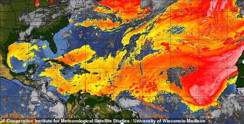
The vast cloud consists of extremely dry, dust-filled air that forms over the Sahara Desert before being carried thousands of miles westward by strong winds.
Light to moderate Saharan dust has already begun drifting into South Florida, including the Miami area, creating hazy skies, suppressing thunderstorm activity and contributing to hotter, drier conditions.
Forecasters said a drier air mass, fueled by an approaching plume of Saharan dust, will move into the region beginning Tuesday.
The dust is expected to continue filtering across the state through the week, with its effects becoming increasingly noticeable by midweek.
The great Blizzard of 2026– days ago this storm was sailing out to sea without harming anything but fish.. as the week drew to a close, we began to see we were about to continue our toxic relationship with the Winter of 2026..
This time red flashing lights of blizzard warnings are gracing New York City, the state of New Jersey, and parts of Pennsylvania.. warnings are pink .. people are miserable.
And as this storm begins to crank up and bomb out, the snowicane will feature 80 mile per hour gusts to create blizzard conditions..
If there was a storm of the century so far this may be it — enough to bring about the likes of Andre Linoge? That is yet to be seen. But born in sin, come on in..
For posterity.. here is the Blizzard Warning for New York City–something that is rare…
...BLIZZARD WARNING REMAINS IN EFFECT FROM 1 PM THIS AFTERNOON TO 6
PM EST MONDAY...

* WHAT...Blizzard conditions expected. Total snow accumulations
  between 16 and 24 inches. Winds gusting as high as 60 mph.

* WHERE...Portions of southern Connecticut and southeast New York.

* WHEN...From 1 PM this afternoon to 6 PM EST Monday.

* IMPACTS...Visibilities may drop below 1/4 mile due to falling and
  blowing snow. Whiteout conditions are expected and will make
  travel treacherous and potentially life-threatening. The strong
  winds and weight of snow on tree limbs may down power lines and
  could cause sporadic power outages. Travel could be very difficult
  to impossible. Areas of blowing snow could significantly reduce
  visibility. The hazardous conditions will impact the Monday
  morning and evening commutes.

* ADDITIONAL DETAILS...Heaviest snow and strongest winds are
  expected tonight into Monday.
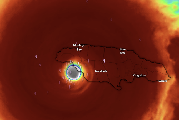
This is what Public Accounts are saying is happening right now on the lost island of Jamaica.
Hospitals across Jamaica have been devastated as Hurricane Melissa tears through the island with Category 5 strength. First responders are calling the situation “beyond critical.”
In St. Elizabeth Parish, the Black River Hospital suffered roof collapses and power loss, forcing staff to evacuate patients as floodwaters rose. Health Minister Christopher Tufton confirmed that at least four major hospitals have sustained severe structural damage, while others operate on emergency power.
Doctors and nurses are working in darkness, using flashlights to treat patients as fuel, oxygen, and supplies run low. Rescue efforts remain stalled by blocked roads and widespread power outages that have left more than half a million Jamaicans without electricity. Officials warn that the country’s health system is nearing collapse as Hurricane Melissa continues to unleash catastrophic winds and flooding across the island.
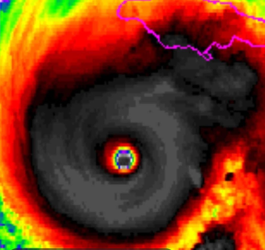
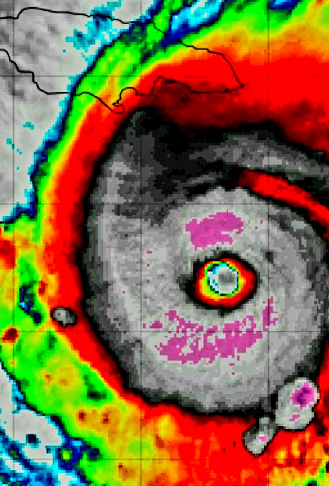
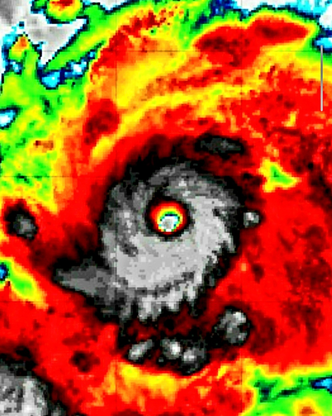
Jamaica is now feeling the full fury of Hurricane Melissa. This is one of the most powerful storms the island has ever faced—and very likely the strongest of 2025. The eye has crossed onto land, and what is unfolding will be etched into the record books.
Wind-speeds have surged into the 175 mph range, with reconnaissance aircraft recording values near 185 mph and a central pressure dropping to 892 millibars—figures that place Melissa among the strongest Atlantic hurricanes ever documented.
What happens now is waiting — and enduring. The eye has taken hold: the damage is being done right now. This is a long-duration event. The storm’s force, its rains, surge, and winds will leave a mark long after its passage. Homes will be flattened, people displaced, infrastructure gutted. Many lives will be forever changed.
If you’re reading this while the storm is underway: stop what you’re doing, offer a prayer for Jamaica. The island is going through a life-changing event. It will never be the same.
This is developing: MELISSA IS NOW ONE OF THE STRONGEST HURRICANES EVER RECORDED IN THE ATLANTIC BASIN.
The new 2PM update now has sustained winds of 175 mph and gusts approaching 220 mph. Pressure now down to 906 mb.
Catastrophic impacts coming to the Island of Jamaica later tonight.
May God have mercy on Jamaica
More .. updated..
…241 MPH WIND GUST! One of the strongest wind gusts ever recorded in a hurricane was just measured by hurricane hunters who continue to fly through Melissa tonight. This extreme wind gust was recorded approximately 700 feet above the ocean’s surface; this phenomenon is absolutely terrifying…
The National Hurricane Center warned on Saturday, “Melissa is still expected to make landfall in Jamaica as an upper-end Category 4 hurricane, which could be the strongest direct landfall for the island since tropical cyclone record keeping has been made in the Atlantic Basin.”
While Melissa could make landfall as a high-end Category 4 storm or even a Category 5, the practical difference between the two is minimal.
There will be catastrophic winds, rainfall, mudslides and impacts from Melissa, regardless of whether the storm strikes as a Category 4 or 5.
Anyone who did not leave Jamaica now cannot.. the window has closed..
Just look at this nightmare as it spins..
https://www.facebook.com/reel/1638441973797872
Earlier Sunday, Minister of Local Government Desmond McKenzie urged residents in low-lying and flood-prone areas to evacuate immediately.
Speaking ahead of the storm, he warned that many communities may not survive the expected flooding. “It is going to be impossible for us, after all the attempts that we have been making…for us to say to our first responders ‘go out and risk your life,’” McKenzie said.
We are praying and hoping.. but we are fearing we will see some really awful news events coming out of Jamaica in the next several hours and upcoming days and weeks..
Strong wording from the National Hurricane Center for Jamaica ahead of Hurricane Melissa:
“Do not venture out of your safe shelter. Catastrophic and life-threatening flash flooding and numerous landslides are likely today through Tuesday. Destructive winds, especially in the mountains, will begin by this evening, leading to extensive infrastructural damage, long-lasting power and communication outages, and isolated communities. Life-threatening storm surge and damaging waves are expected along the southern coast through Tuesday.”
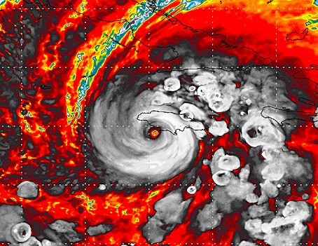
In just 18 hours Melissa has rapidly intensified from a 70 MPH Tropical Storm to a 140 MPH Cat. 4 hurricane–at least at the time this is written. It is undoubtedly going to zoom to a Cat. 5 before landfall in Jamaica Tuesday morning.
It is also being predicted that it will be the worst Jamaica has ever experienced..
It would appear that the worst of the fearful predictions are coming true..
Sustained winds of 170+ and gust of 200+ MPH are possible at maximum if it continues at this rate. The highest sustained wind speed ever recorded in the Atlantic basin was 190 MPH from Hurricane Allen in 1980.
Watching this storm in motion is frightening..
Hurricane Melissa has explosively intensified from a Category 1 to Category 4 storm in just the last 12 hours.
This is the worst-case scenario for Jamaica, as Melissa could make landfall as a Category 5 storm early Tuesday morning. pic.twitter.com/9cq0RLnKib
This looks too br a recipe for a disaster over certain parts of the CARRIBEAN…
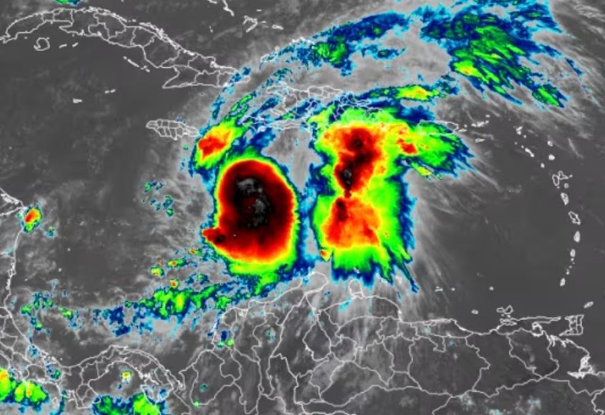
Tropical Storm Melissa is forecast to rapily intensify into a major hurricane this weekend as it lashes Jamaica and parts of the northern Caribbean, bringing days of life-threatening, potentially catastrophic impact.
More..
Jamaica looks to be the epicenter for the worst of Melissa’s triple threat of extreme rainfall flooding, wind damage and storm surge. Melissa could make landfall on Jamaica late Monday or early Tuesday.Haiti also continues to be in thick of Melissa’s destructive flood and landslide threats.
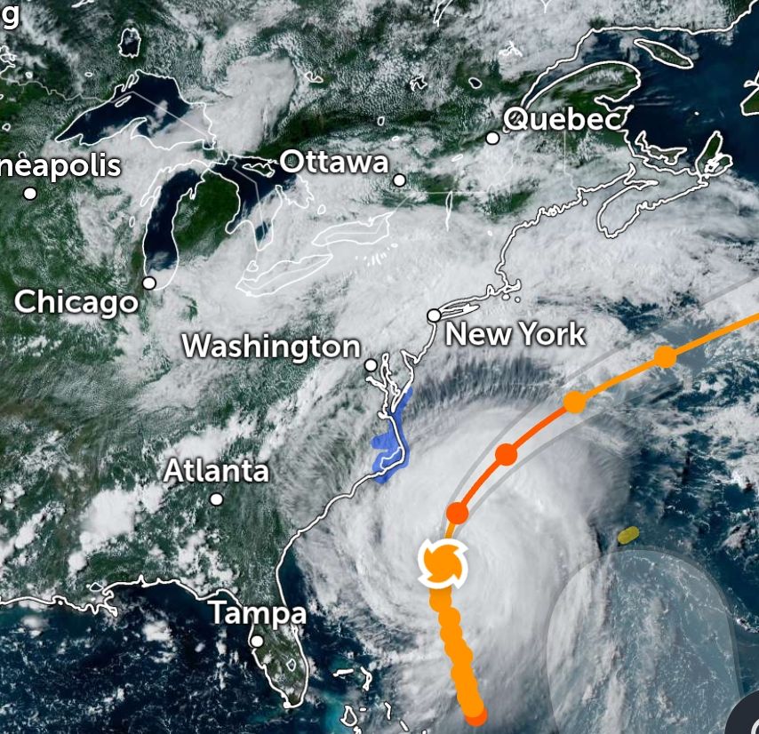
Hurricane Erin has taken a few turns that have now created a much more dramatic situation for the coastline—reaching all the way up into the Mid-Atlantic and even New York City.
Storm surge is now expected for New York Harbor, Raritan Bay, the waters around Staten Island, the entire Jersey Shore, all of Delaware, Maryland, Virginia, and North Carolina’s coastlines, as well as the northern half of South Carolina’s coastline.
For days, official storm trackers maintained that Erin would remain safely offshore. But many amateur forecasters began noticing a subtle westward trend several days ago. That trend has continued. While the storm is still expected to stay mostly out to sea, portions of the East Coast will now face impacts that simply weren’t predicted earlier in the week.
Hurricane Erin on Saturday strengthened into a fearsome Category 5 hurricane with sustained winds of 160 mph as the storm traveled west over the Atlantic, according to the National Hurricane Center.
And 200 mph gusts…
This could go down in history as one of the strongest storms ever in the Atlantic. At this point, there are some observations of a slight wobble to the south and west, and that needs to be monitored pretty closely because the track still has the storm quickly taking a sharp northern turn and out to sea, avoiding all land and Bermuda. Let’s hope the fish enjoy Hurricane Erin, and we don’t.
In the meantime, any deviation to the path could create obstacles for landfall or at least beaches. But let’s hope the current track stays exactly like it is, and we don’t have to worry about Hurricane Erin making its own weather pattern due to its strength. Everyone will be watching this one closely.
And if nothing happens, as we predict it will not based off of the current forecasts, it does offer a cautionary tale. Hurricanes are very strong this time of year in a very hot Atlantic Ocean, and this could portend trouble eventually for the Northeast—areas that have not seen the impacts of a Category 4 or 5 storm in our lifetime.