Look how enormous this sucker is!

More…
It is set to miss the East Coast ..


Clearly, the path of hurricane Lee consistently is taking it off the coast of the United States.
But it’s just too close for comfort.. we aren’t ready to call it a fish storm just yet.
Developing..
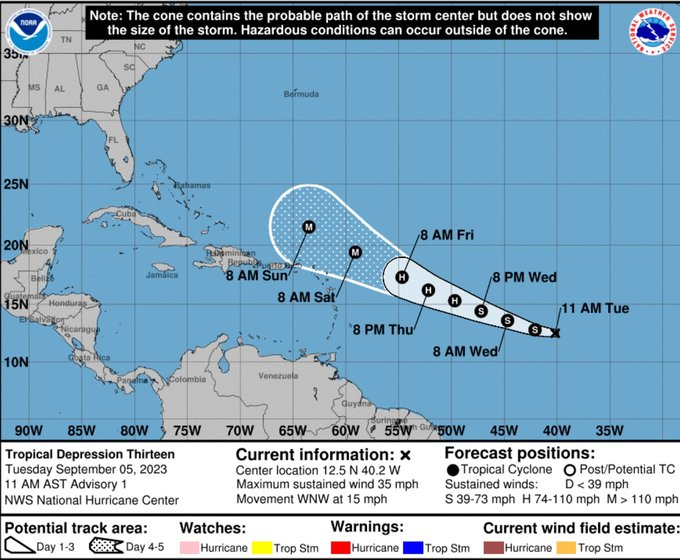
This soon to be monster storm in the Atlantic Ocean will be named hurricane Lee..
It will also certainly immediately become a category 5 ..
https://x.com/ericburriswesh/status/1699157885723574667?s=46&t=qL5_BCLlr1TaPKqR_awfZQ
We are hoping and praying this stays a storm for eh fishes…. But that’s just wishes.
Lee will churn..
Will land he burn?
A storm for the sea?
We shall see ..

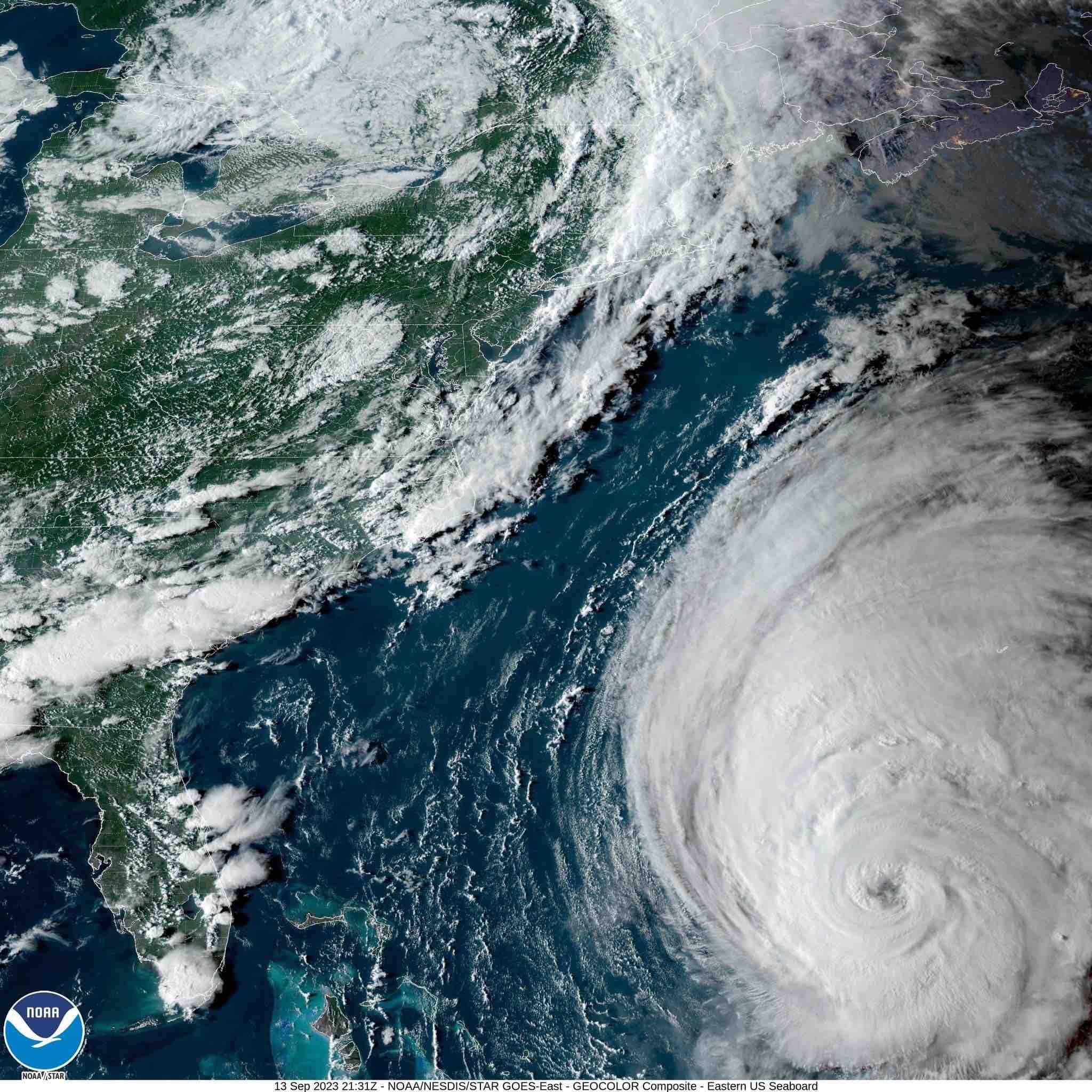
Look at this satellite image!! Idalia grew rapidly before it hit land..

When Idalia made landfall Wednesday morning it had maximum sustained winds near 125 mph (205 kph).
The low-lying marsh area faced a predicted storm surge of up to 15 feet!
There are populated areas in the region, including Gainesville, where the University of Florida canceled classes through Wednesday…
Developing..
At the time of this posting, Idalia is currently located just under 200 miles southwest of Tampa and is moving to the north at 16 mph, according to the National Hurricane Center’s latest forecast. CNN is tracking the storm’s path.
Idalia’s landfall strength and storm surge could reach once-in-a-lifetime levels along parts of Florida’s Gulf Coast, including in the Big Bend and Tampa Bay areas. Officials have warned surge could climb as high as 10 to 15 feet in the Big Bend area.
A video from Ryan Hall, y’all.
Expect rapid intensification at this time.. the storm has blossomed further to the south than expected ..
Developing..
Tropical Storm Idalia is strengthening quickly as it churns toward Florida and could become a dangerous Category 3 storm as it approaches the coast with a mix of heavy rains, high winds and damaging storm surge.
Idalia is expected to intensify into a hurricane Monday and make landfall on Wednesday morning near the Big Bend of Florida as a dangerous major hurricane, according to the National Hurricane Center.
As the storm intensifies, “life-threatening storm surge and dangerous winds” are “becoming increasingly likely for portions of Florida,” the hurricane center said early Monday..

The Washington POST is reporting this information, it is now being dispatched on other news sources as well..
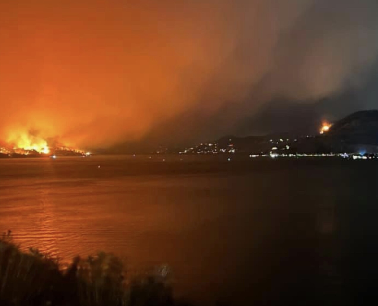
The Hawaii power utility believed to have started the deadly Lahaina fire removed damaged power poles and other equipment from a key fire scene, potentially affecting evidence that is part of an official investigation into how the blaze ignited.
Hawaiian Electric — which acted quickly to restore power on the island after Aug. 8 — hauled away fallen poles, power lines, transformers, conductors and other equipment from near a Lahaina substation starting around Aug. 12, documents show, before investigators from the federal Bureau of Alcohol, Tobacco, Firearms and Explosives (ATF) arrived on scene. ATF usually responds to bombings and shootings. This is only the agency’s third wildland fire investigation, a spokesperson said. Usually, it’s the U.S. Forest Service’s role, but since the Maui fires were not on any national forest lands, ATF is the primary federal investigative force.
Those actions may have violated national guidelines on how utilities should handle and preserve evidence after a wildfire and deprives investigators the opportunity to view any poles or downed lines in an undisturbed condition before or after the fire started, according to court documents, letters and other records obtained by The Washington Post.
— Read on townhall.com/tipsheet/mattvespa/2023/08/25/how-hawaiian-electric-just-compromised-the-investigation-into-the-maui-wildfires-n2627513
Tired of living through weather history yet? It’s relentless.. and becoming so common it just stops feeling historic and instead just awful and redundant ..
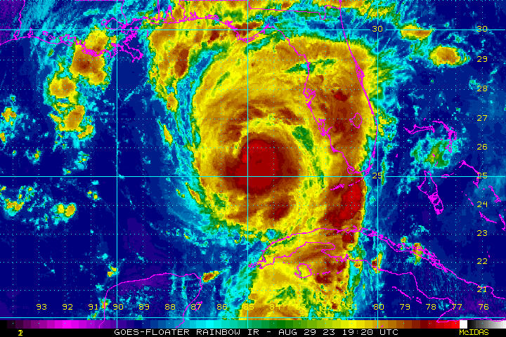
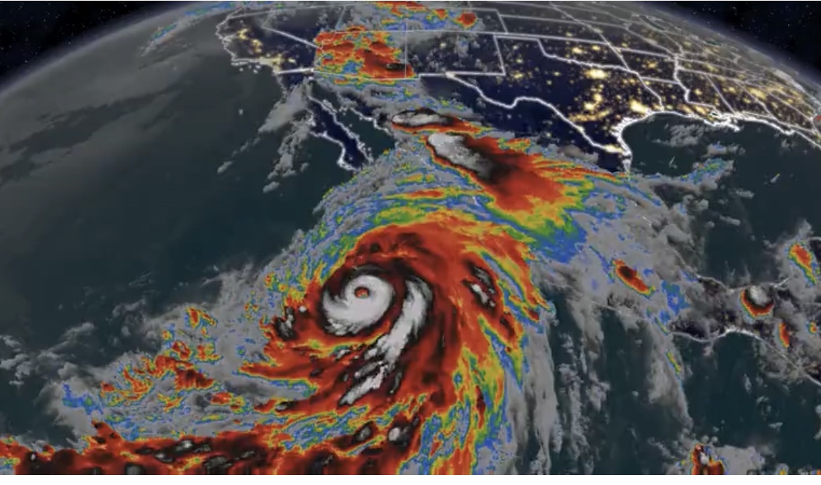
Hurricane Hilary has intensified into a Category 4 storm as it nears Mexico’s Baja California peninsula, yet is expected to weaken over the weekend as it brings rain and the threat of flooding to parts of the Southwest US.
Some are worried that it could hit a cat 5 before weakening ..
Hilary was churning about 425 miles south of Cabo San Lucas, Mexico, early Friday morning with sustained winds of 140 mph with stronger gusts, the National Hurricane Center said.
The updated wind cone (featured as this story’s main image) has an increased chance of tropical storm-strength winds hitting the San Diego area, up from 30%-40% to 40%-50%.
There is also an outside chance of what’s known as a “wet” Santa Ana event, which could bring increased winds, as the circulation pushes north.
More..
Thanks to Hilary, “multiple years’ worth of precipitation could potentially fall in some of the driest parts of California,” Daniel Swain, a climate scientist at the University of California at Los Angeles, said Wednesday.
Among those spots is Death Valley, California, the hottest place on Earth. Death Valley typically receives about 2 inches of rain across an entire year, according to NWS data. Moisture from Hilary could unleash enough rain to give Death Valley 1 to 2 years worth of rainfall in a single day. And Las Vegas could get 2 to 4 inches of rain. It only averages 3.75 inches of rain a year.
Prolonged rain may oversaturate the ground and overwhelm waterways, potentially worsening the flood threat.