CNN caves to pressure and becomes journalism again?


New Orleans may be without power and air conditioning for more than three weeks in the wake of Hurricane Ida, which roared ashore with more powerful winds than Hurricane Katrina, according to utility owner Entergy Corp.
Almost 750,000 homes and businesses were without power across Louisiana as of 7:26 p.m. local time on Sunday, according to Poweroutage.us, which tracks utility outages.
The blackouts were concentrated in the southeastern tip of the state that includes New Orleans and where Ida made its U.S. landfall.
I thought Robin hated me,” Hawke, who had his breakthrough role in the Peter Weir film, shared. “He had a habit of making a ton of jokes on set. At 18, I found that incredibly irritating. He wouldn’t stop and I wouldn’t laugh at anything he did.”
Hawke, who played a teenage student taught by Williams’s unconventional and inspiring English teacher, remembered his co-star needling him during filming, but said he’s since come to see the older actor’s perspective.
Williams on the set of Dead Poets Society. (Photo: Touchstone Pictures/Getty Images)
“There was this scene in the film when he makes me spontaneously make up a poem in front of the class,” he recalled. “He made this joke at the end of it, saying that he found me intimidating. I thought it was a joke. As I get older, I realize there is something intimidating about young people’s earnestness, their intensity. It is intimidating — to be the person they think you are. Robin was that for me.”
What an interesting perspective. This movie has been one of the most enduring films of all time, a CLASSIC immediately then when it was released and no less important now for generation sense. There’s a certain ritual, almost a coming-of-age moment, in which dead poet society is filling a void in the mid time frame of life ..
This is also interesting look back from actor Ethan Hawke and his perspective on Robin Williams at the time..
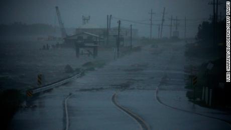
Storm surge and strong winds from Hurricane Ida stopped the flow of the Mississippi River near New Orleans on Sunday and actually caused it to reverse — something the US Geological Survey says is “extremely uncommon.
“Ida made landfall near Port Fourchon, Louisiana, early Sunday afternoon as an extremely dangerous Category 4 hurricane with winds of 150 mph, the National Hurricane Center (NHC) said.
All Orleans Parish customers without power due to “catastrophic transmission damage,” according to Entergy New Orleans.
A company spokesperson said the storm had caused a “load imbalance to the company’s transmission and generation” and that Entergy is “making every effort to identify and rectify.”
Now focus is on flooding and also the pumps in the Big Easy..

More than 95% of the Gulf of Mexico’s oil production has been shut down thanks to Hurricane Ida, regulators said Sunday, indicating the hurricane is having a significant impact on energy supply.
As of 11:30 a.m. CT, personnel have been evacuated from a total of 288 oil-and-gas production platforms, according to the Bureau of Safety and Environmental Enforcement. That represents about 51% of the manned platforms in the Gulf of Mexico.
The agency said all 11 rigs in the Gulf of Mexico have also been evacuated, and a total of 1.7 million barrels of daily oil production in the Gulf of Mexico has been shut-in – the equivalent to 95.7% of the region’s total output.
— Read on www.cnn.com/us/live-news/hurricane-ida-updates-08-29-21/
Ida has made landfall in Port Fouchon just about exact time the 16th anniversary of Katrina..
Gas prices, as in 2005, are expected to immensely soar as a result of Ida ..
BREAKING: HURRICANE IDA FORECAST TO PRODUCE RECORD BREAKING STORM.SURGE IN PORTIONS OF LOUISIANA.
A lethal 12-16′ storm surge is now forecast to impact portions of Louisiana…while 2 feet or more of rain is expected to fall.
Ida will likely go into the record books as the worst storm to hit Louisiana and one of the most violent hurricanes to.ever hit the U.S.
There are already countless reports of power outages, and other effects from Ida even before landfall at this hour.
Destructive category 4 or greater strength winds are likely, bringing about devastating impacts across portions of Southeast Louisiana mainly along and to the west of the I-55 corridor including metro Baton Rouge, western portions of metro New Orleans, and the Houma metropolitan area. In this area, the National Weather Service warns of structural damage to sturdy buildings, some with complete roof
and wall failures. The National Weather Service says there will be complete destruction of mobile homes. Damage to all structures will be greatly accentuated by large airborne projectiles. There will be thousands of large trees snapped or uprooted along with fences and
roadway signs blown over; many roads will be impassable from large debris, and more within urban or heavily wooded places. Many bridges, causeways, and access routes could be impassable for an extended period of time. The wind will also knock-out power and communication for weeks, months, or longer for some.
— Read on weatherboy.com/hurricane-ida-heads-to-louisiana-with-epic-storm-surge-massive-floods-destructive-winds/
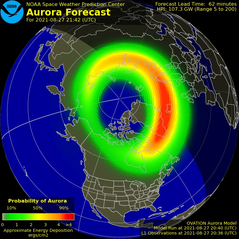
As though the weather on the planet wasn’t already scary enough, cue the sun: a C3 flare erupted from sunspot region 2859 on the Sun on August 26 and appears to have sent a solar blast towards the Earth..
The National Weather Service’s Space Weather Prediction Center confirmed a partial halo CME took place. In a statement released by the SWPC, analysis and modeling are now underway to determine if there may be any possible geoeffective component to this CME.
It appears this solar explosion set-off a “solar tsunami”.
A solar tsunami, also known as a Moreton Wave or a Moreton-Ramsey Wave, is the signature of a large-scale solar corona shock wave generated by solar flares. Initially spotted in the late 1950’s, technology deployed by NASA in 2009 confirmed the presence and the mechanics of such a tsunami…
The best guess for the potential impact of the “Solar Tsunami” will be August 30 ..
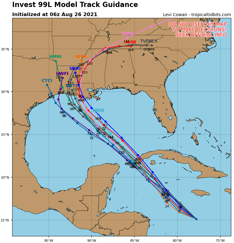
This is beginning to be a striking similarity to Hurricane Katrina–if not worse..16 years to the exact date of when the storm struck New Orleans..
THE LATEST WEATHER WARNING FROM NHC:
WTNT24 KNHC 272041
TCMAT4

HURRICANE IDA FORECAST/ADVISORY NUMBER   6
NWS NATIONAL HURRICANE CENTER MIAMI FL       AL092021
2100 UTC FRI AUG 27 2021

CHANGES IN WATCHES AND WARNINGS WITH THIS ADVISORY...

A STORM SURGE WARNING HAS BEEN ISSUED FROM EAST OF ROCKEFELLER
WILDLIFE REFUGE LOUISIANA TO THE MISSISSIPPI/ALABAMA BORDER
INCLUDING VERMILION BAY...LAKE BORGNE...LAKE PONTCHARTRAIN...AND
LAKE MAUREPAS.

A HURRICANE WARNING HAS BEEN ISSUED FOR THE COAST OF LOUISIANA FROM
INTRACOASTAL CITY TO THE MOUTH OF THE PEARL RIVER...INCLUDING LAKE
PONTCHARTRAIN...LAKE MAUREPAS...AND METROPOLITAN NEW ORLEANS.

A TROPICAL STORM WARNING HAS BEEN ISSUED FOR THE NORTHERN GULF
COAST FROM THE MOUTH OF THE PEARL RIVER TO THE MISSISSIPPI/ALABAMA
BORDER. A TROPICAL STORM WARNING HAS ALSO BEEN ISSUED FOR THE COAST
OF LOUISIANA FROM WEST OF INTRACOASTAL CITY TO CAMERON.

SUMMARY OF WATCHES AND WARNINGS IN EFFECT...

A STORM SURGE WARNING IS IN EFFECT FOR...
* EAST OF ROCKEFELLER WILDLIFE REFUGE LOUISIANA TO THE
MISSISSIPPI/ALABAMA BORDER
* VERMILION BAY...LAKE BORGNE...LAKE PONTCHARTRAIN...AND LAKE
MAUREPAS

A HURRICANE WARNING IS IN EFFECT FOR...
* CUBAN PROVINCES OF PINAR DEL RIO AND ARTEMISA...AND THE ISLE OF
YOUTH
* INTRACOASTAL CITY LOUISIANA TO THE MOUTH OF THE PEARL RIVER
* LAKE PONTCHARTRAIN...LAKE MAUREPAS...AND METROPOLITAN NEW ORLEANS

A STORM SURGE WATCH IS IN EFFECT FOR...
* SABINE PASS TO ROCKEFELLER WILDLIFE REFUGE LOUISIANA
* MOBILE BAY

A HURRICANE WATCH IS IN EFFECT FOR...
* CAMERON LOUISIANA TO WEST OF INTRACOASTAL CITY LOUISIANA
* MOUTH OF THE PEARL RIVER TO THE MISSISSIPPI/ALABAMA BORDER

A TROPICAL STORM WARNING IS IN EFFECT FOR...
* CUBAN PROVINCES OF MATANZAS...MAYABEQUE...AND HAVANA
* CAMERON LOUISIANA TO WEST OF INTRACOASTAL CITY LOUISIANA
* MOUTH OF THE PEARL RIVER TO THE MISSISSIPPI/ALABAMA BORDER

A TROPICAL STORM WATCH IS IN EFFECT FOR...
* MISSISSIPPI/ALABAMA BORDER TO THE ALABAMA/FLORIDA BORDER

A STORM SURGE WARNING MEANS THERE IS A DANGER OF LIFE-THREATENING
INUNDATION...FROM RISING WATER MOVING INLAND FROM THE
COASTLINE...DURING THE NEXT 36 HOURS IN THE INDICATED LOCATIONS.
FOR A DEPICTION OF AREAS AT RISK...PLEASE SEE THE NATIONAL WEATHER
SERVICE STORM SURGE WATCH/WARNING GRAPHIC...AVAILABLE AT
HURRICANES.GOV.  THIS IS A LIFE-THREATENING SITUATION.  PERSONS
LOCATED WITHIN THESE AREAS SHOULD TAKE ALL NECESSARY ACTIONS TO
PROTECT LIFE AND PROPERTY FROM RISING WATER AND THE POTENTIAL FOR
OTHER DANGEROUS CONDITIONS.  PROMPTLY FOLLOW EVACUATION AND OTHER
INSTRUCTIONS FROM LOCAL OFFICIALS.

A HURRICANE WARNING MEANS THAT HURRICANE CONDITIONS ARE EXPECTED
SOMEWHERE WITHIN THE WARNING AREA.  A WARNING IS TYPICALLY ISSUED
36 HOURS BEFORE THE ANTICIPATED FIRST OCCURRENCE OF
TROPICAL-STORM-FORCE WINDS...CONDITIONS THAT MAKE OUTSIDE
PREPARATIONS DIFFICULT OR DANGEROUS.  PREPARATIONS TO PROTECT LIFE
AND PROPERTY SHOULD BE RUSHED TO COMPLETION.

A TROPICAL STORM WARNING MEANS THAT TROPICAL STORM CONDITIONS ARE
EXPECTED SOMEWHERE WITHIN THE WARNING AREA WITHIN 36 HOURS.

A STORM SURGE WATCH MEANS THERE IS A POSSIBILITY OF LIFE-
THREATENING INUNDATION...FROM RISING WATER MOVING INLAND FROM THE
COASTLINE...IN THE INDICATED LOCATIONS DURING THE NEXT 48 HOURS.

A HURRICANE WATCH MEANS THAT HURRICANE CONDITIONS ARE POSSIBLE
WITHIN THE WATCH AREA.  A WATCH IS TYPICALLY ISSUED 48 HOURS
BEFORE THE ANTICIPATED FIRST OCCURRENCE OF TROPICAL-STORM-FORCE
WINDS...CONDITIONS THAT MAKE OUTSIDE PREPARATIONS DIFFICULT OR
DANGEROUS.

A TROPICAL STORM WATCH MEANS THAT TROPICAL STORM CONDITIONS ARE
POSSIBLE WITHIN THE WATCH AREA...GENERALLY WITHIN 48 HOURS.

INTERESTS ELSEWHERE ALONG THE NORTHERN U.S. GULF COAST SHOULD
MONITOR THE PROGRESS OF THIS SYSTEM.  INTERESTS IN THE DRY TORTUGAS
SHOULD ALSO MONITOR THE PROGRESS OF IDA.

HURRICANE CENTER LOCATED NEAR 22.1N  83.2W AT 27/2100Z
POSITION ACCURATE WITHIN  20 NM

PRESENT MOVEMENT TOWARD THE NORTHWEST OR 320 DEGREES AT  13 KT

ESTIMATED MINIMUM CENTRAL PRESSURE  985 MB
MAX SUSTAINED WINDS  70 KT WITH GUSTS TO  85 KT.
64 KT....... 20NE   0SE   0SW   0NW.
50 KT....... 40NE  30SE   0SW  20NW.
34 KT....... 80NE  60SE  40SW  60NW.
12 FT SEAS..  0NE 120SE  45SW   0NW.
WINDS AND SEAS VARY GREATLY IN EACH QUADRANT.  RADII IN NAUTICAL
MILES ARE THE LARGEST RADII EXPECTED ANYWHERE IN THAT QUADRANT.

REPEAT...CENTER LOCATED NEAR 22.1N  83.2W AT 27/2100Z
AT 27/1800Z CENTER WAS LOCATED NEAR 21.6N  82.7W

FORECAST VALID 28/0600Z 23.5N  84.8W
MAX WIND  85 KT...GUSTS 105 KT.
64 KT... 20NE  15SE  10SW  20NW.
50 KT... 40NE  30SE  20SW  40NW.
34 KT...100NE  80SE  50SW  90NW.

FORECAST VALID 28/1800Z 25.3N  86.9W
MAX WIND 105 KT...GUSTS 130 KT.
64 KT... 20NE  20SE  15SW  20NW.
50 KT... 40NE  40SE  30SW  40NW.
34 KT...110NE  90SE  60SW 100NW.

FORECAST VALID 29/0600Z 27.1N  89.0W
MAX WIND 115 KT...GUSTS 140 KT.
64 KT... 30NE  25SE  20SW  30NW.
50 KT... 50NE  50SE  30SW  50NW.
34 KT...130NE 100SE  70SW 110NW.

FORECAST VALID 29/1800Z 28.6N  90.6W
MAX WIND 120 KT...GUSTS 145 KT.
64 KT... 30NE  25SE  20SW  25NW.
50 KT... 50NE  50SE  40SW  40NW.
34 KT...120NE 110SE  70SW  90NW.

FORECAST VALID 30/0600Z 30.0N  91.3W...INLAND
MAX WIND  80 KT...GUSTS 100 KT.
50 KT... 40NE  40SE  30SW  20NW.
34 KT...100NE 100SE  60SW  70NW.

FORECAST VALID 30/1800Z 31.5N  91.1W...INLAND
MAX WIND  40 KT...GUSTS  50 KT.
34 KT... 50NE  90SE  30SW  30NW.

EXTENDED OUTLOOK. NOTE...ERRORS FOR TRACK HAVE AVERAGED NEAR 150 NM
ON DAY 4 AND 175 NM ON DAY 5...AND FOR INTENSITY NEAR 15 KT EACH DAY

OUTLOOK VALID 31/1800Z 34.4N  89.3W...INLAND
MAX WIND  30 KT...GUSTS  40 KT.

OUTLOOK VALID 01/1800Z 36.0N  86.0W...POST-TROP/REMNT LOW
MAX WIND  20 KT...GUSTS  30 KT.

REQUEST FOR 3 HOURLY SHIP REPORTS WITHIN 300 MILES OF 22.1N  83.2W

INTERMEDIATE PUBLIC ADVISORY...WTNT34 KNHC/MIATCPAT4...AT 28/0000Z

NEXT ADVISORY AT 28/0300Z

$$
FORECASTER BROWN